Aerial Photography Helicopter Service
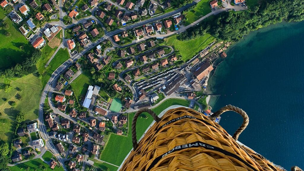
Aerial photography using helicopters provides an unparalleled perspective, capturing stunning high-resolution images and videos from the sky. This service is essential for a wide range of industries, including real estate, tourism, film production, construction, mapping, and emergency response.
24×7 Guest Support no:- +91 9289445248
Email:- airpushpakaviation@gmail.com
Key Features and Benefits of Aerial Photography Helicopter Service:
Unmatched Views and Angles:
Helicopters can fly at various altitudes and angles, offering flexibility in capturing a wide range of aerial views. Whether it’s a panoramic shot of a cityscape, detailed close-ups of a construction site, or sweeping views of a coastal area, helicopters provide an ideal platform for diverse photographic needs.
Unlike drones, helicopters can fly at much higher altitudes and cover larger areas, making them especially useful for capturing wide landscapes or urban environments.
Access to Hard-to-Reach Locations:
Helicopters can reach remote, inaccessible, or restricted areas that might be challenging for other aircraft or ground-based photography setups. This is especially useful in locations such as mountains, offshore facilities, large construction sites, or dense urban areas.
Helicopter aerial photography is also ideal for capturing images of areas with limited space for takeoff or landing, as they require much less open area compared to drones.
Stability and Precision:
Helicopters are designed for stable flight, offering smooth and steady platforms for high-quality photography. With the right equipment, such as gimbals or gyroscopic stabilizers, aerial shots are incredibly clear and sharp, even in challenging conditions.
This stability is crucial for capturing professional-grade photos and videos, particularly when dealing with fast-moving subjects or low-light conditions like sunrise or sunset.
High-Quality Equipment:
Helicopter services typically use high-end cameras and lenses to capture high-resolution images or video footage. These include DSLR cameras, mirrorless cameras, or specialized aerial cameras equipped with large sensors and advanced stabilization systems.
The ability to use large, high-quality lenses enables photographers to capture detailed images with excellent clarity and depth, even from high altitudes.
Quick Setup and Flexibility:
Helicopter photography services offer fast response times, enabling clients to schedule flights based on their needs. Helicopters can be ready to fly with minimal setup, making them ideal for urgent or time-sensitive projects, such as capturing weather events, breaking news, or real-time construction progress.
Flexibility also extends to flight routes, allowing photographers to tailor the flight path to get the best possible shots of a specific location or event.
Common Uses of Helicopter Aerial Photography Services:
Real Estate:
Aerial photography is widely used in the real estate industry to showcase properties, particularly large estates, commercial buildings, or residential developments. High-quality aerial shots of a property can give prospective buyers or investors a better sense of the layout, surroundings, and nearby amenities.
Drone vs. Helicopter: While drones are frequently used for real estate photography, helicopters are preferred for larger properties or where a wider aerial view is required. Helicopters also offer the advantage of being able to capture imagery over larger distances and areas.
Film and Television:
Helicopters are essential for capturing breathtaking shots for movies, television shows, and commercials. They provide directors with the ability to capture wide, sweeping shots of landscapes, city skylines, and action scenes, offering dynamic perspectives that help tell a story visually.
The combination of skilled pilots and camera operators in helicopters allows for creative, high-quality footage, whether it’s for aerial shots of landscapes or chasing action scenes.
Construction and Infrastructure Monitoring:
Helicopter photography is crucial for capturing aerial images of large construction projects, infrastructure developments, and urban planning. It allows project managers, architects, and engineers to monitor progress, document milestones, and assess the impact of construction from above.
This service is especially valuable for surveying construction sites or inspecting infrastructure like bridges, highways, and power plants, where aerial views provide a better understanding of the site’s condition or progress.
Land and Property Surveys:
Aerial photography is often used in land surveying and mapping. For large properties or areas that are difficult to navigate on foot, helicopter photography allows for an efficient and comprehensive survey, capturing detailed images for analysis and planning.
It is also used in agriculture to monitor crops, evaluate land conditions, or assist in environmental studies.
Tourism and Marketing:
Tourism companies and marketing agencies use helicopter photography to create promotional content showcasing scenic locations, landmarks, and tourist attractions. Stunning aerial shots of natural wonders, cities, or resorts can capture the imagination of potential visitors, boosting tourism campaigns.
Helicopter tours also provide a unique opportunity for individuals to experience aerial photography firsthand, offering them unforgettable views of popular destinations.
Emergency Response and Disaster Management:
In cases of natural disasters or emergencies, helicopters are used to provide real-time aerial imagery that can help authorities assess damage, plan rescue operations, or monitor evolving situations such as wildfires, floods, or oil spills.
Aerial photographs are invaluable for mapping disaster zones, directing resources to critical areas, and understanding the scope of the emergency.
Environmental and Wildlife Studies:
Helicopter services are often used for environmental monitoring, wildlife surveys, and conservation efforts. Aerial imagery can be used to track animal migration, monitor wildlife populations, assess environmental conditions, or document illegal activities such as poaching or deforestation.
Researchers can cover large areas in a short amount of time, enabling them to gather data in remote or otherwise inaccessible locations.
Advantages of Helicopter-Based Aerial Photography Over Drones:
Altitude and Coverage:
Helicopters can fly at much higher altitudes compared to drones, allowing for broader coverage and the ability to capture more expansive landscapes in a single shot. This is particularly useful for large-scale projects like real estate developments, cityscapes, or large natural reserves.
Longer Flight Duration:
Helicopters can stay in the air for a longer period compared to drones, which have a limited flight time due to battery life. This allows for longer photography sessions and the ability to cover more ground in a single trip.
Safety and Stability:
Helicopters are generally more stable than drones, especially in challenging weather conditions. Helicopter pilots are highly trained and can operate in a wide range of environments and weather conditions, whereas drones may struggle with wind, rain, or other obstacles.
Larger Payload and Equipment:
Helicopters can carry more extensive and heavier equipment, including larger cameras, advanced lenses, and stabilization systems, which can be beneficial for high-end production work or large-scale surveys that require superior image quality.

At Air Pushpak Aviation, we take immense pride in being India’s premier provider of luxury helicopter and private charter services.
We deliver an unparalleled blend of safety, efficiency, and exclusivity, ensuring every journey is not just a trip—but a world-class experience tailored to exceed your expectations.
Quick Link
Connect Us
2025 © All Rights Air Pushpak Aviation Pvt Ltd.